
Carte topographique Bad Rodach
Carte interactive
Cliquez sur la carte pour afficher l’altitude.
À propos de cette carte
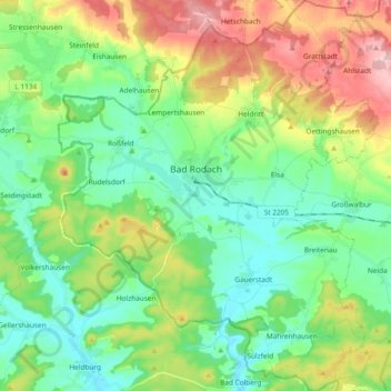
Nom : Carte topographique Bad Rodach, altitude, relief.
Lieu : Bad Rodach, Landkreis Coburg, Bayern, 96476, Deutschland (50.27308 10.71232 50.39271 10.86477)
Altitude moyenne : 352 m
Altitude minimum : 284 m
Altitude maximum : 492 m
Autres cartes topographiques
Cliquez sur une carte pour visualiser sa topographie, son altitude et son relief.
Untersiemau
Deutschland > Bayern > Landkreis Coburg
Untersiemau, Landkreis Coburg, Bayern, 96253, Deutschland
Altitude moyenne : 319 m