
Carte topographique Red Feather Lakes
Carte interactive
Cliquez sur la carte pour afficher l’altitude.
À propos de cette carte
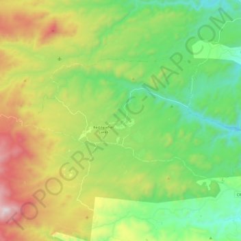
Nom : Carte topographique Red Feather Lakes, altitude, relief.
Altitude moyenne : 2 551 m
Altitude minimum : 2 137 m
Altitude maximum : 3 314 m
Red Feather Lakes is located in north-central Larimer County at 40°48′28″N 105°34′43″W / 40.80778°N 105.57861°W / 40.80778; -105.57861 (40.807820, -105.578641), at an elevation of 8,100 to 8,500 feet (2,500 to 2,600 m). Via Red Feather Lakes Road, it is 24 miles (39 km) west of U.S. Route 287 at Livermore and 45 miles (72 km) northwest of Fort Collins, the county seat.