
Carte topographique Kawerau
Carte interactive
Cliquez sur la carte pour afficher l’altitude.
À propos de cette carte
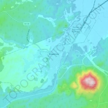
Nom : Carte topographique Kawerau, altitude, relief.
Altitude moyenne : 107 m
Altitude minimum : 14 m
Altitude maximum : 780 m
Autres cartes topographiques
Cliquez sur une carte pour visualiser sa topographie, son altitude et son relief.
Lake Pupuwharau
New Zealand > Bay of Plenty > Kawerau
Lake Pupuwharau, East Bank Road, Kawerau, Kawerau District, Bay of Plenty, 3127, New Zealand
Altitude moyenne : 67 m
Lake Rotoitipaku
New Zealand > Bay of Plenty > Kawerau
Lake Rotoitipaku, Spencer Avenue, Kawerau, Kawerau District, Bay of Plenty, 3127, New Zealand
Altitude moyenne : 45 m