
Carte topographique Kepulauan Sangihe
Carte interactive
Cliquez sur la carte pour afficher l’altitude.
Kepulauan Sangihe
Topography of the islands mostly consists of hills and steep topography for bigger islands such as Sangihe and Siau. Around 55.4% of land area in the regency has slope above 40%. Soil composition consist of alluvium, which mostly used for residential areas. Elevation varies from 0 to 1,800 meters above sea level depending on the location. Main economic center of the regency, Tahuna, has average elevation of 250 meters above sea level. The regency has three active volcanoes, and experiences frequent earthquakes. Two of three volcanoes are underwater. The region is quite resilient to erosion because of dense vegetation usually found on its coastal region, while most human settlements are found on higher altitudes in the middle of islands. However, because of its steep topography, the region is prone to landslides especially during bad weather.
À propos de cette carte
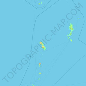
Nom : Carte topographique Kepulauan Sangihe, altitude, relief.
Lieu : Kepulauan Sangihe, North Sulawesi, Indonesia (1.78935 125.05577 5.56633 126.59089)
Altitude moyenne : 2 m
Altitude minimum : 0 m
Altitude maximum : 1 696 m
Autres cartes topographiques
Cliquez sur une carte pour visualiser sa topographie, son altitude et son relief.