
Carte topographique Isla Guadalupe
Carte interactive
Cliquez sur la carte pour afficher l’altitude.
À propos de cette carte
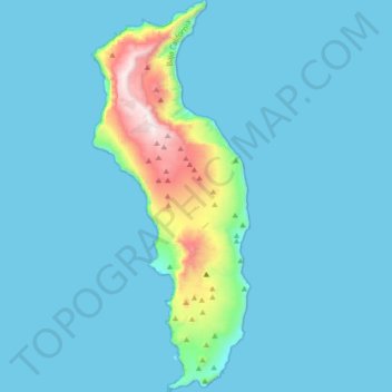
Nom : Carte topographique Isla Guadalupe, altitude, relief.
Altitude moyenne : 113 m
Altitude minimum : 0 m
Altitude maximum : 1 284 m
Campo Pista is located at the small airport, near the center of the island (29°01′24.04″N 118°16′21.75″W / 29.0233444°N 118.2727083°W / 29.0233444; -118.2727083, elevation:592 m, direction:05/23).[1] Airport Isla Guadalupe (ICAO Code MMGD) has a 1,200-metre-long (3,900 ft) runway. At the end of the runway near threshold 5 is the wreckage of a Lockheed Model 18 Lodestar, which overshot the runway during landing. A North American B-25J-30/32 Mitchell, BMM-3501 (c/n 44-86712), bomber wrecked on the opposite end of the runway, after suffering serious damage in trying to take-off overloaded (29°01′36.10″N 118°16′2.98″W / 29.0266944°N 118.2674944°W / 29.0266944; -118.2674944). Based on historical Google Earth imagery, this B-25 wreckage appears to have been removed from the location between October, 2005, and June, 2006.
Autres cartes topographiques
Cliquez sur une carte pour visualiser sa topographie, son altitude et son relief.
Francisco Zarco (Valle de Guadalupe)
Mexico > Baja California > Municipio de Ensenada
Francisco Zarco (Valle de Guadalupe), Municipio de Ensenada, Baja California, Mexico
Altitude moyenne : 384 m
San Vicente
Mexico > Baja California > Municipio de Ensenada
San Vicente, Municipio de Ensenada, Baja California, 22900, Mexico
Altitude moyenne : 157 m
Ensenada
Mexico > Baja California > Municipio de Ensenada
Ensenada, Municipio de Ensenada, Baja California, Mexico
Altitude moyenne : 184 m