
Carte topographique Cawsane
Carte interactive
Cliquez sur la carte pour afficher l’altitude.
À propos de cette carte
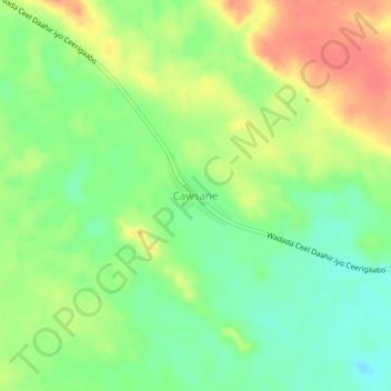
Nom : Carte topographique Cawsane, altitude, relief.
Lieu : Cawsane, Las Khorey District, Sanaag, Somaliland, Somalia (10.56288 48.78722 10.60288 48.82722)
Altitude moyenne : 788 m
Altitude minimum : 763 m
Altitude maximum : 816 m
Autres cartes topographiques
Cliquez sur une carte pour visualiser sa topographie, son altitude et son relief.
Manna
Somalia > Sanaag > Las Khorey District
Manna, Las Khorey District, Sanaag, Somalia
Altitude moyenne : 527 m