
Carte topographique Aurora
Carte interactive
Cliquez sur la carte pour afficher l’altitude.
À propos de cette carte
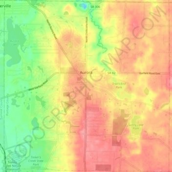
Nom : Carte topographique Aurora, altitude, relief.
Lieu : Aurora, Portage County, Ohio, 44202, United States (41.27529 -81.39183 41.34827 -81.29823)
Altitude moyenne : 335 m
Altitude minimum : 284 m
Altitude maximum : 371 m
Autres cartes topographiques
Cliquez sur une carte pour visualiser sa topographie, son altitude et son relief.
Windham Township
United States > Ohio > Portage County
Windham Township, Portage County, Ohio, United States
Altitude moyenne : 315 m
Randolph Township
United States > Ohio > Portage County
Randolph Township, Portage County, Ohio, 44265, United States
Altitude moyenne : 353 m
Kent
United States > Ohio > Portage County > Kent > Kent
Kent, Portage County, Ohio, 44240, United States
Altitude moyenne : 329 m
Atwater
United States > Ohio > Portage County > Atwater
Atwater, Atwater Township, Portage County, Ohio, United States
Altitude moyenne : 346 m
Kent
United States > Ohio > Portage County
Kent, Portage County, Ohio, United States
Altitude moyenne : 328 m
Streetsboro
United States > Ohio > Portage County
Streetsboro, Portage County, Ohio, 44241, United States
Altitude moyenne : 335 m