
Carte topographique Ľubietová
Carte interactive
Cliquez sur la carte pour afficher l’altitude.
Ľubietová
Ľubietová is part of the Banská Bystrica District in the Banská Bystrica Region. It is situated 25 km east from the town of Banská Bystrica. It lies at an altitude of 491 metres and covers an area of 61 km². The geographic center of Slovakia, the Hrb mountain, is located near the village.
À propos de cette carte
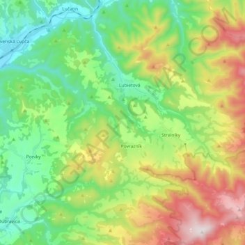
Nom : Carte topographique Ľubietová, altitude, relief.
Altitude moyenne : 683 m
Altitude minimum : 366 m
Altitude maximum : 1 282 m