
Carte topographique Ropczyce
Carte interactive
Cliquez sur la carte pour afficher l’altitude.
Ropczyce
Ropczyce is located east of Kraków and west of Rzeszów. The coordinates for Ropczyce: Latitude 50°0500' and Longitude 21°6167. In DMS or Degree, Minutes, & Seconds; Latitude 50°2'60N and Longitude is 21°37'0E. Its elevation is 240 metres (787 feet) above sea level. The time zone for Poland is UTC+1.
À propos de cette carte
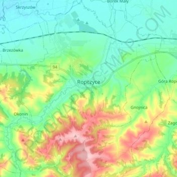
Nom : Carte topographique Ropczyce, altitude, relief.
Altitude moyenne : 250 m
Altitude minimum : 190 m
Altitude maximum : 382 m