
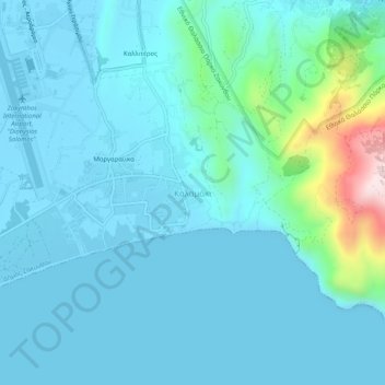
Carte topographique Kalamaki
Carte interactive
Cliquez sur la carte pour afficher l’altitude.
À propos de cette carte
Nom : Carte topographique Kalamaki, altitude, relief.
Altitude moyenne : 58 m
Altitude minimum : -4 m
Altitude maximum : 461 m
Autres cartes topographiques
Cliquez sur une carte pour visualiser sa topographie, son altitude et son relief.
Lithakia
Greece > Peloponnese, Western Greece and the Ionian > Zakynthos Regional Unit
Lithakia, Zakynthos Municipality, Zakynthos Regional Unit, Ioanian Islands, Peloponnese, Western Greece and the Ionian, 290 92, Greece
Altitude moyenne : 153 m
Ναυάγιο
Greece > Peloponnese, Western Greece and the Ionian > Zakynthos Regional Unit
Ναυάγιο, κ. Βολίμων, Zakynthos Municipality, Zakynthos Regional Unit, Ioanian Islands, Peloponnese, Western Greece and the Ionian, Greece
Altitude moyenne : 125 m
Zakynthos
Greece > Peloponnese, Western Greece and the Ionian > Zakynthos Regional Unit
Zakynthos, Zakynthos Regional Unit, Ioanian Islands, Peloponnese, Western Greece and the Ionian, Greece
Altitude moyenne : 82 m
Vardiola in Tsilivi
Greece > Peloponnese, Western Greece and the Ionian > Zakynthos Regional Unit > Planos
Vardiola in Tsilivi, Τσιβιλή - Κάτω Γερακάρι, κ. Τραγακίου, Planos, Zakynthos Municipality, Zakynthos Regional Unit, Ioanian Islands, Peloponnese, Western Greece and the Ionian, 291 00, Greece
Altitude moyenne : 12 m
Alykanas
Greece > Peloponnese, Western Greece and the Ionian > Zakynthos Regional Unit
Alykanas, Zakynthos Municipality, Zakynthos Regional Unit, Ioanian Islands, Peloponnese, Western Greece and the Ionian, 290 90, Greece
Altitude moyenne : 16 m
Laganas
Greece > Peloponnese, Western Greece and the Ionian > Zakynthos Regional Unit > Laganas
Laganas, Zakynthos Municipality, Zakynthos Regional Unit, Ioanian Islands, Peloponnese, Western Greece and the Ionian, 29092, Greece
Altitude moyenne : 8 m