
Carte topographique Manila
Carte interactive
Cliquez sur la carte pour afficher l’altitude.
Manila
Almost all of Manila sits on top of centuries of prehistoric alluvial deposits built by the waters of the Pasig River and on some land reclaimed from Manila Bay. Manila's land has been altered substantially by human intervention, with considerable land reclamation along the waterfronts since the American colonial times. Some of the city's natural variations in topography have been evened out. As of 2013, Manila had a total area of 42.88 square kilometers.
À propos de cette carte
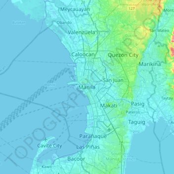
Nom : Carte topographique Manila, altitude, relief.
Altitude moyenne : 13 m
Altitude minimum : -3 m
Altitude maximum : 220 m
Autres cartes topographiques
Cliquez sur une carte pour visualiser sa topographie, son altitude et son relief.