
Carte topographique Three Sisters
Carte interactive
Cliquez sur la carte pour afficher l’altitude.
Three Sisters
The area is part of the Colorado Plateau. The elevation of the valley floor ranges from 5,000 to 6,000 feet (1,500 to 1,800 m) above sea level. The floor is largely siltstone of the Cutler Group, or sand derived from it, deposited by the meandering rivers that carved the valley. The valley's vivid red color comes from iron oxide exposed in the weathered siltstone. The darker, blue-gray rocks in the valley get their color from manganese oxide.
À propos de cette carte
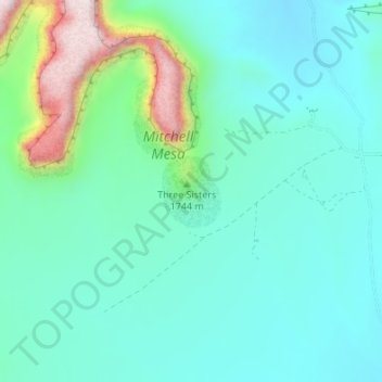
Nom : Carte topographique Three Sisters, altitude, relief.
Lieu : Three Sisters, Navajo County, Arizona, United States (36.94620 -110.10047 36.95130 -110.09526)
Altitude moyenne : 1 664 m
Altitude minimum : 1 571 m
Altitude maximum : 1 985 m
Autres cartes topographiques
Cliquez sur une carte pour visualiser sa topographie, son altitude et son relief.