
Carte topographique Karamay
Carte interactive
Cliquez sur la carte pour afficher l’altitude.
À propos de cette carte
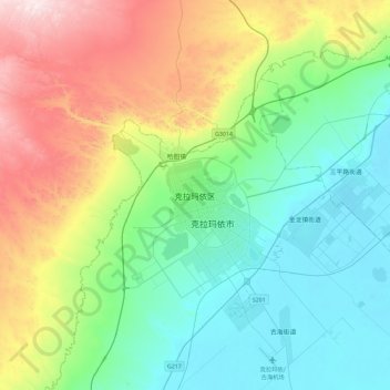
Nom : Carte topographique Karamay, altitude, relief.
Lieu : Karamay, Karamay District, Karamay City, Xinjiang, China (45.44038 84.70614 45.76038 85.02614)
Altitude moyenne : 510 m
Altitude minimum : 267 m
Altitude maximum : 1 097 m
Karamay is located in the northwest of the Dzungarian basin, with an average elevation of 400 meters (1,300 ft). Its administrative area ranges in latitude from 44° 07' to 46° 08' N and in longitude from 80° 44' to 86° 01' E, and has a maximal 240 km (150 mi) north-south extent and reaches 110 km (68 mi) in east-west width. It borders Hoboksar Mongol Autonomous County to the northeast, Shawan County to the southeast, Toli County and Wusu to the west, and Kuytun to the south.