
Carte topographique Arosa
Carte interactive
Cliquez sur la carte pour afficher l’altitude.
À propos de cette carte
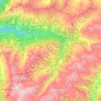
Nom : Carte topographique Arosa, altitude, relief.
Lieu : Arosa, Plessur, Grisons, Switzerland (46.72958 9.58322 46.87360 9.80700)
Altitude moyenne : 1 985 m
Altitude minimum : 694 m
Altitude maximum : 2 959 m
Before 2017, the municipality was in the Schanfigg sub-district of the Plessur district, after that date it was part of the Plessur Region. Located on the south-east slope of the Weisshorn chain, the town of Arosa is at the top of the Schanfigg valley at the foot of the Aroser Weisshorn (2,653 m (8,704 ft)). Adjoining are the areas of Innerarosa, Dorf-Obersee, Untersee and Maran-Prätschli at an elevation of 1,690 and 1,950 meters (5,540 and 6,400 ft).
Autres cartes topographiques
Cliquez sur une carte pour visualiser sa topographie, son altitude et son relief.
Churwalden
Switzerland > Grisons > Plessur
Churwalden, Plessur, Grisons, Switzerland
Altitude moyenne : 1 688 m