
Carte topographique Osterburg
Carte interactive
Cliquez sur la carte pour afficher l’altitude.
À propos de cette carte
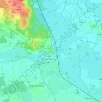
Nom : Carte topographique Osterburg, altitude, relief.
Altitude moyenne : 29 m
Altitude minimum : 19 m
Altitude maximum : 74 m
Autres cartes topographiques
Cliquez sur une carte pour visualiser sa topographie, son altitude et son relief.
Falkenberg
Duitsland > Saksen-Anhalt > Stendal > Altmärkische Wische
Falkenberg, Altmärkische Wische, Seehausen, Stendal, Saksen-Anhalt, Duitsland
Altitude moyenne : 23 m
Stendal
Duitsland > Saksen-Anhalt > Stendal
Stendal, Saksen-Anhalt, 39576, Duitsland
Altitude moyenne : 41 m