
Carte topographique Bruny Island
Carte interactive
Cliquez sur la carte pour afficher l’altitude.
À propos de cette carte
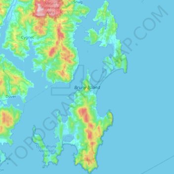
Nom : Carte topographique Bruny Island, altitude, relief.
Lieu : Bruny Island, Alonnah, Kingborough, Tasmania, Australia (-43.51605 147.09180 -43.06352 147.43326)
Altitude moyenne : 59 m
Altitude minimum : -3 m
Altitude maximum : 806 m
Outside of its settlements, the island is covered with grazing fields and large tracts of dry eucalyptus forest. Inland forests have been logged, but other large sections—mostly along the south-eastern coast—are preserved as the South Bruny National Park. While the seaward side of the island features two long beaches—Adventure Bay and Cloudy Bay—it is for the most part extremely rugged, with cliffs of dolerite that are over 200 metres (660 ft) AHD in altitude. Bruny's channel side is far more sheltered and a favourite fishing and recreational boating area for local and interstate visitors. Adventure Bay is located on the eastern side of the isthmus, while Isthmus Bay is located on the western side.