

Faire un don
Équipez-vous pour votre prochaine aventure :
En tant que Partenaire Amazon, ce site perçoit une commission sur les achats éligibles sans surcoût pour vous.
Carte topographique Vilzing
Cliquez sur la carte pour afficher l’altitude.
Faire un don
Équipez-vous pour votre prochaine aventure :
En tant que Partenaire Amazon, ce site perçoit une commission sur les achats éligibles sans surcoût pour vous.
À propos de cette carte
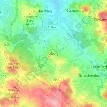
Nom : Carte topographique Vilzing, altitude, relief.
Lieu : Vilzing, Cham, Landkreis Cham, Bayern, 93413, Deutschland (49.15703 12.65706 49.19703 12.69706)
Altitude moyenne : 422 m
Altitude minimum : 373 m
Altitude maximum : 498 m
Faire un don
Équipez-vous pour votre prochaine aventure :
En tant que Partenaire Amazon, ce site perçoit une commission sur les achats éligibles sans surcoût pour vous.
Autres cartes topographiques
Cliquez sur une carte pour visualiser sa topographie, son altitude et son relief.

Schwedenschanze
Deutschland > Bayern > Landkreis Cham > Cham > Chammünster
Der Burgstall Schwedenschanze, bei der es sich vermutlich um die Reichsburg Cham handelt, ist eine abgegangene Höhenburg (Wallburg) auf dem 415 Meter hohen Galgenberg 35 Meter über dem Zusammenfluss von Chamb und Regen in der Gemarkung Altenstadt der Stadt Cham im oberpfälzischen Landkreis Cham in Bayern.…
Altitude moyenne : 385 m