
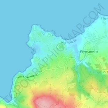
Carte topographique Hameau des Pelletiers
Carte interactive
Cliquez sur la carte pour afficher l’altitude.
À propos de cette carte
Nom : Carte topographique Hameau des Pelletiers, altitude, relief.
Altitude moyenne : 26 m
Altitude minimum : -1 m
Altitude maximum : 134 m
Autres cartes topographiques
Cliquez sur une carte pour visualiser sa topographie, son altitude et son relief.
Hameau du Cap Lévi
France > Normandie > Manche > Fermanville
Hameau du Cap Lévi, Fermanville, Cherbourg, Manche, Normandie, France métropolitaine, 50840, France
Altitude moyenne : 15 m
Intheville
France > Normandie > Manche > Fermanville
Intheville, Fermanville, Cherbourg, Manche, Normandie, France métropolitaine, 50840, France
Altitude moyenne : 28 m
Inglemare
France > Normandie > Manche > Fermanville
Inglemare, Fermanville, Cherbourg, Manche, Normandie, France métropolitaine, 50840, France
Altitude moyenne : 21 m