
Carte topographique Koatzet
Carte interactive
Cliquez sur la carte pour afficher l’altitude.
À propos de cette carte
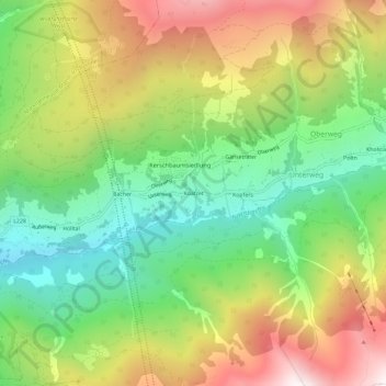
Nom : Carte topographique Koatzet, altitude, relief.
Altitude moyenne : 1 621 m
Altitude minimum : 1 066 m
Altitude maximum : 2 369 m
Autres cartes topographiques
Cliquez sur une carte pour visualiser sa topographie, son altitude et son relief.
Navistal
Österreich > Tirol > Bezirk Innsbruck-Land > Unterweg
Navistal, Unterweg, Gemeinde Navis, Bezirk Innsbruck-Land, Tirol, 6145, Österreich
Altitude moyenne : 1 675 m