
Faire un don
Équipez-vous pour votre prochaine aventure :
En tant que Partenaire Amazon, ce site perçoit une commission sur les achats éligibles sans surcoût pour vous.
Carte topographique Anna Maria island
Cliquez sur la carte pour afficher l’altitude.
Faire un don
Équipez-vous pour votre prochaine aventure :
En tant que Partenaire Amazon, ce site perçoit une commission sur les achats éligibles sans surcoût pour vous.
Anna Maria island
Anna Maria Island features a flat, sandy topography typical of a barrier island on the Gulf Coast. With an average elevation of around 15 feet above sea level, the terrain includes broad beaches, low dunes, and narrow stretches of sandy soil, making it highly vulnerable to storm surges and tidal flooding. The island's main geographical feature is its seven-mile shoreline, edged with white sand and framed by shallow, clear waters of the Gulf, ideal for beachgoers and marine life alike. Vegetated dunes and mangrove-lined shores are common on the leeward side, offering a natural barrier and habitat for local wildlife, including shorebirds and sea turtles. Additionally, the island’s layout includes multiple narrow inlets and lagoons, enhancing its characteristic coastal scenery and supporting a diverse ecosystem adapted to this unique, low-lying coastal environment.
Faire un don
Équipez-vous pour votre prochaine aventure :
En tant que Partenaire Amazon, ce site perçoit une commission sur les achats éligibles sans surcoût pour vous.
À propos de cette carte
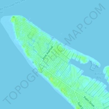
Nom : Carte topographique Anna Maria island, altitude, relief.
Altitude moyenne : 2 m
Altitude minimum : -1 m
Altitude maximum : 11 m
Faire un don
Équipez-vous pour votre prochaine aventure :
En tant que Partenaire Amazon, ce site perçoit une commission sur les achats éligibles sans surcoût pour vous.
Autres cartes topographiques
Cliquez sur une carte pour visualiser sa topographie, son altitude et son relief.
Parrish
United States > Florida > Manatee County
Parrish features a predominantly flat terrain with an average elevation of approximately 36 feet above sea level. The area's landscape is characterized by gently rolling hills and low-lying regions, making it typical of the Central Florida topography. Surrounding Parrish are numerous wetlands and drainage…
Altitude moyenne : 12 m
Bradenton
United States > Florida > Manatee County
Bradenton features a predominantly flat and gently undulating terrain typical of the region. The city is situated near the confluence of the Manatee River, which meanders through the area and flows into the Gulf of Mexico, creating a series of lush riverbanks and estuaries that support diverse ecosystems.…
Altitude moyenne : 5 m
Myakka City
United States > Florida > Manatee County
Myakka City (also Myakka) is an unincorporated community in southeastern Manatee County, Florida, United States. It lies along State Road 70 near the city of Bradenton, the county seat of Manatee County. Its elevation is 43 feet (13 m), and it is located at 27°20′59″N 82°9′41″W / 27.34972°N…
Altitude moyenne : 14 m
Faire un don
Équipez-vous pour votre prochaine aventure :
En tant que Partenaire Amazon, ce site perçoit une commission sur les achats éligibles sans surcoût pour vous.
Faire un don
Équipez-vous pour votre prochaine aventure :
En tant que Partenaire Amazon, ce site perçoit une commission sur les achats éligibles sans surcoût pour vous.
Faire un don
Équipez-vous pour votre prochaine aventure :
En tant que Partenaire Amazon, ce site perçoit une commission sur les achats éligibles sans surcoût pour vous.
Myakka City
United States > Florida > Manatee County
Myakka City (also Myakka) is an unincorporated community in southeastern Manatee County, Florida, United States. It lies along State Road 70 near the city of Bradenton, the county seat of Manatee County. Its elevation is 43 feet (13 m), and it is located at 27°20′59″N 82°9′41″W / 27.34972°N…
Altitude moyenne : 14 m
Faire un don
Équipez-vous pour votre prochaine aventure :
En tant que Partenaire Amazon, ce site perçoit une commission sur les achats éligibles sans surcoût pour vous.
Bradenton
United States > Florida > Manatee County
Bradenton was affected by World War II like many other cities in Florida and the United States. During the war, Manatee County had its own Civil Defense battalion in it with two subunits existing in Bradenton and another for nearby Manatee. A recreational center was opened in March 1942 at a building on the…
Altitude moyenne : 5 m
Faire un don
Équipez-vous pour votre prochaine aventure :
En tant que Partenaire Amazon, ce site perçoit une commission sur les achats éligibles sans surcoût pour vous.
Faire un don
Équipez-vous pour votre prochaine aventure :
En tant que Partenaire Amazon, ce site perçoit une commission sur les achats éligibles sans surcoût pour vous.
Bradenton
United States > Florida > Manatee County
Bradenton was affected by World War II like many other cities in Florida and the United States. During the war, Manatee County had its own Civil Defense battalion in it with two subunits existing in Bradenton and another for nearby Manatee. A recreational center was opened in March 1942 at a building on the…
Altitude moyenne : 5 m
Bradenton
United States > Florida > Manatee County
Bradenton would be affected by World War II like many other cities in Florida and the United States. During the war, Manatee County would have its own Civil Defense battalion in it with two subunits existing in Bradenton and another for nearby Manatee. A recreational center would be opened in March 1942 at a…
Altitude moyenne : 5 m
Bradenton
United States > Florida > Manatee County
Bradenton was affected by World War II like many other cities in Florida and the United States. During the war, Manatee County had its own Civil Defense battalion in it with two subunits existing in Bradenton and another for nearby Manatee. A recreational center was opened in March 1942 at a building on the…
Altitude moyenne : 5 m
Faire un don
Équipez-vous pour votre prochaine aventure :
En tant que Partenaire Amazon, ce site perçoit une commission sur les achats éligibles sans surcoût pour vous.