
Faire un don
Équipez-vous pour votre prochaine aventure :
En tant que Partenaire Amazon, ce site perçoit une commission sur les achats éligibles sans surcoût pour vous.
Carte topographique Taliparamba
Cliquez sur la carte pour afficher l’altitude.
Faire un don
Équipez-vous pour votre prochaine aventure :
En tant que Partenaire Amazon, ce site perçoit une commission sur les achats éligibles sans surcoût pour vous.
Taliparamba
Taliparamba is located at 12°03′N 75°21′E / 12.05°N 75.35°E / 12.05; 75.35.[10] It has an average elevation of 56 metres (184 ft) above sea level. The surrounding area (including the villages of Pattuvam, Pariyaram, Kuttiyeri, Karimbam, and Koonam) features lush green fields and low rolling hills. The Kuppam and Valapattanam rivers surround the town and the Arabian Sea is only 14 kilometres (8.7 mi) to the west of the city.
Faire un don
Équipez-vous pour votre prochaine aventure :
En tant que Partenaire Amazon, ce site perçoit une commission sur les achats éligibles sans surcoût pour vous.
À propos de cette carte
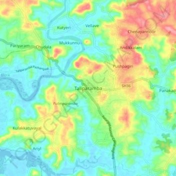
Nom : Carte topographique Taliparamba, altitude, relief.
Lieu : Taliparamba, Kannur district, Kerala, 670141, India (12.00251 75.31698 12.08251 75.39698)
Altitude moyenne : 36 m
Altitude minimum : -2 m
Altitude maximum : 109 m
Faire un don
Équipez-vous pour votre prochaine aventure :
En tant que Partenaire Amazon, ce site perçoit une commission sur les achats éligibles sans surcoût pour vous.