
Carte topographique Central District
Carte interactive
Cliquez sur la carte pour afficher l’altitude.
À propos de cette carte
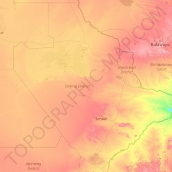
Nom : Carte topographique Central District, altitude, relief.
Lieu : Central District, Botswana (-24.07902 23.61542 -18.87902 28.81542)
Altitude moyenne : 1 007 m
Altitude minimum : 546 m
Altitude maximum : 1 786 m
Autres cartes topographiques
Cliquez sur une carte pour visualiser sa topographie, son altitude et son relief.
Mababe
Botswana > District du Nord-Ouest
Mababe, District du Nord-Ouest, Botswana
Altitude moyenne : 927 m
Désert du Kalahari
Désert du Kalahari, District de Ghanzi, Botswana
Altitude moyenne : 1 168 m
Ghanzi
Botswana > District de Ghanzi > Ghanzi
Ghanzi, District de Ghanzi, Botswana
Altitude moyenne : 1 143 m
Maun
Botswana > District du Nord-Ouest > Maun
Maun, District du Nord-Ouest, P.O. BOX 217, Botswana
Altitude moyenne : 942 m
Sedibeng
Botswana > District du Sud > Sedibeng
Sedibeng, District du Sud, Botswana
Altitude moyenne : 1 179 m
Kweneng
Botswana > District de Kweneng > Kweneng
Kweneng, District de Kweneng, Botswana
Altitude moyenne : 1 113 m
Okavango Delta
Botswana > District du Nord-Ouest
Okavango Delta, District du Nord-Ouest, Botswana
Altitude moyenne : 955 m
Semane
Botswana > District du Sud > Semane
Semane, District du Sud, Botswana
Altitude moyenne : 1 145 m
Makgadikgadi Pans Game Reserve
Makgadikgadi Pans Game Reserve, District Central, Botswana
Altitude moyenne : 917 m
Central Kalahari Game Reserve
Central Kalahari Game Reserve, District de Ghanzi, Botswana
Altitude moyenne : 1 009 m