
Carte topographique Hamburg Township
Carte interactive
Cliquez sur la carte pour afficher l’altitude.
À propos de cette carte
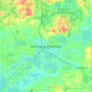
Nom : Carte topographique Hamburg Township, altitude, relief.
Lieu : Hamburg Township, Livingston County, Michigan, United States (42.42517 -83.91081 42.51470 -83.78725)
Altitude moyenne : 275 m
Altitude minimum : 253 m
Altitude maximum : 331 m
Autres cartes topographiques
Cliquez sur une carte pour visualiser sa topographie, son altitude et son relief.
Howell
United States > Michigan > Livingston County
Howell, Livingston County, Michigan, United States
Altitude moyenne : 282 m
Hartland Township
United States > Michigan > Livingston County
Hartland Township, Livingston County, Michigan, 48353, United States
Altitude moyenne : 304 m
Whitmore Lake
United States > Michigan > Livingston County > Green Oak Township > Whitmore Lake
Whitmore Lake, Green Oak Township, Livingston County, Michigan, 48189, United States
Altitude moyenne : 276 m
Hell
United States > Michigan > Livingston County > Putnam Township
Hell, Putnam Township, Livingston County, Michigan, United States
Altitude moyenne : 277 m