
Faire un don
Équipez-vous pour votre prochaine aventure :
En tant que Partenaire Amazon, ce site perçoit une commission sur les achats éligibles sans surcoût pour vous.
Carte topographique Qu'Appelle
Cliquez sur la carte pour afficher l’altitude.
Faire un don
Équipez-vous pour votre prochaine aventure :
En tant que Partenaire Amazon, ce site perçoit une commission sur les achats éligibles sans surcoût pour vous.
Qu'Appelle
Qu'Appelle is located in the Indian Head Plain of the Aspen Parkland ecoregion on the parkland of the Qu'Appelle flood plain. Qu'Appelle's elevation is 662.90 m (2,174.9 ft) above sea level. The area is characterised by lush rolling grasslands, interspersed with poplar bluffs (in prairie Canadian terminology poplar groves surrounding sloughs) and open sloughs. Qu'Appelle is located in the transition zone between the Qu'Appelle River and the corresponding Qu'Appelle Valley and the Canadian Prairies.
Faire un don
Équipez-vous pour votre prochaine aventure :
En tant que Partenaire Amazon, ce site perçoit une commission sur les achats éligibles sans surcoût pour vous.
À propos de cette carte
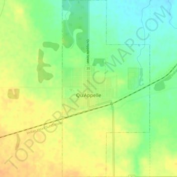
Nom : Carte topographique Qu'Appelle, altitude, relief.
Lieu : Qu'Appelle, Division No. 6, Saskatchewan, S0G 4A0, Canada (50.52776 -103.88483 50.55699 -103.86206)
Altitude moyenne : 651 m
Altitude minimum : 633 m
Altitude maximum : 665 m
Faire un don
Équipez-vous pour votre prochaine aventure :
En tant que Partenaire Amazon, ce site perçoit une commission sur les achats éligibles sans surcoût pour vous.