
Faire un don
Équipez-vous pour votre prochaine aventure :
En tant que Partenaire Amazon, ce site perçoit une commission sur les achats éligibles sans surcoût pour vous.
Carte topographique Nantahala National Forest
Cliquez sur la carte pour afficher l’altitude.
Faire un don
Équipez-vous pour votre prochaine aventure :
En tant que Partenaire Amazon, ce site perçoit une commission sur les achats éligibles sans surcoût pour vous.
Nantahala National Forest
The terrain varies in elevation from 5,800 feet (1,767.8 m) at Lone Bald in Jackson County, to 1,200 feet (365.8 m) in Cherokee County along the Hiwassee River below the Appalachia Dam. It is the home of many western NC waterfalls. The last part of the Mountain Waters Scenic Byway travels through this forest. The total area under management is 531,270 acres (830.11 sq. mi.; 2,149.97 km2). In descending order of land area it is located in parts of Macon, Graham, Cherokee, Jackson, Clay, Swain and Transylvania counties.
Faire un don
Équipez-vous pour votre prochaine aventure :
En tant que Partenaire Amazon, ce site perçoit une commission sur les achats éligibles sans surcoût pour vous.
À propos de cette carte
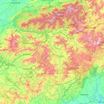
Nom : Carte topographique Nantahala National Forest, altitude, relief.
Altitude moyenne : 781 m
Altitude minimum : 199 m
Altitude maximum : 2 014 m
Faire un don
Équipez-vous pour votre prochaine aventure :
En tant que Partenaire Amazon, ce site perçoit une commission sur les achats éligibles sans surcoût pour vous.
Autres cartes topographiques
Cliquez sur une carte pour visualiser sa topographie, son altitude et son relief.
Faire un don
Équipez-vous pour votre prochaine aventure :
En tant que Partenaire Amazon, ce site perçoit une commission sur les achats éligibles sans surcoût pour vous.
Faire un don
Équipez-vous pour votre prochaine aventure :
En tant que Partenaire Amazon, ce site perçoit une commission sur les achats éligibles sans surcoût pour vous.
Highlands
United States > North Carolina > Macon County > Highlands
Highlands was founded in 1875 after its two founders, Samuel Truman Kelsey and Clinton Carter Hutchinson, drew lines from Chicago to Savannah and from New Orleans to New York City. They felt that the place where these lines met would eventually become a great trading center and commercial crossroads. Highlands…
Altitude moyenne : 1 090 m
Little Tennessee River
United States > North Carolina > Macon County > Franklin > East Franklin
Altitude moyenne : 641 m
Faire un don
Équipez-vous pour votre prochaine aventure :
En tant que Partenaire Amazon, ce site perçoit une commission sur les achats éligibles sans surcoût pour vous.
Franklin
United States > North Carolina > Macon County > Franklin
Franklin is located at 35°10′52″N 83°22′54″W / 35.18111°N 83.38167°W / 35.18111; -83.38167 (35.181144, -83.381685). The elevation of Franklin is 2119 ft.
Altitude moyenne : 665 m
Faire un don
Équipez-vous pour votre prochaine aventure :
En tant que Partenaire Amazon, ce site perçoit une commission sur les achats éligibles sans surcoût pour vous.
Faire un don
Équipez-vous pour votre prochaine aventure :
En tant que Partenaire Amazon, ce site perçoit une commission sur les achats éligibles sans surcoût pour vous.