
Carte topographique Wigmore
Carte interactive
Cliquez sur la carte pour afficher l’altitude.
À propos de cette carte
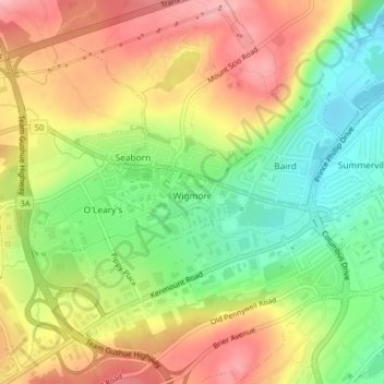
Nom : Carte topographique Wigmore, altitude, relief.
Altitude moyenne : 118 m
Altitude minimum : 52 m
Altitude maximum : 183 m
Autres cartes topographiques
Cliquez sur une carte pour visualiser sa topographie, son altitude et son relief.
Newfound Pond
Canada > Newfoundland and Labrador > St. John's
Newfound Pond, St. John's, Newfoundland, Newfoundland and Labrador, Canada
Altitude moyenne : 157 m
Cape Spear
Canada > Newfoundland and Labrador > St. John's
Cape Spear, St. John's, Newfoundland, Newfoundland and Labrador, Canada
Altitude moyenne : 7 m
Cape Bay
Canada > Newfoundland and Labrador > St. John's
Cape Bay, St. John's, Newfoundland, Newfoundland and Labrador, Canada
Altitude moyenne : 21 m
Signal Hill National Historic Site
Canada > Newfoundland and Labrador > St. John's
Signal Hill National Historic Site, 230, Quidi Vidi, Churchill Park, St. John's, Newfoundland and Labrador, Canada
Altitude moyenne : 29 m
Blackhead
Canada > Newfoundland and Labrador > St. John's > Blackhead
Blackhead, St. John's, Newfoundland and Labrador, Canada
Altitude moyenne : 48 m