
Carte topographique Lisburn
Carte interactive
Cliquez sur la carte pour afficher l’altitude.
À propos de cette carte
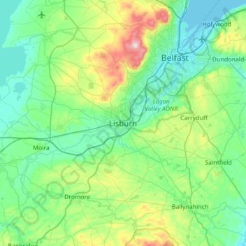
Nom : Carte topographique Lisburn, altitude, relief.
Altitude moyenne : 92 m
Altitude minimum : -2 m
Altitude maximum : 471 m
Autres cartes topographiques
Cliquez sur une carte pour visualiser sa topographie, son altitude et son relief.
Randalstown
United Kingdom > Northern Ireland > County Antrim
Randalstown, County Antrim, Northern Ireland, BT41 3AD, United Kingdom
Altitude moyenne : 57 m
Larne
United Kingdom > Northern Ireland > County Antrim
Larne, County Antrim, Northern Ireland, BT40 1JS, United Kingdom
Altitude moyenne : 54 m
Belfast
United Kingdom > Northern Ireland > County Antrim
Belfast, County Antrim, Northern Ireland, United Kingdom
Altitude moyenne : 92 m
Carrickfergus
United Kingdom > Northern Ireland > County Antrim
Carrickfergus, County Antrim, Ulster, Northern Ireland, BT38 7AF, United Kingdom
Altitude moyenne : 49 m
Antrim
United Kingdom > Northern Ireland > County Antrim > Antrim
Antrim, County Antrim, Northern Ireland, BT41 4AR, United Kingdom
Altitude moyenne : 50 m
Ballymena
United Kingdom > Northern Ireland > County Antrim > Ballymena
Ballymena, County Antrim, Northern Ireland, BT43 6AH, United Kingdom
Altitude moyenne : 74 m
Old Mill
United Kingdom > Northern Ireland > County Antrim > Ballygally > Old Mill
Old Mill, Ballygally, County Antrim, Northern Ireland, BT40 2RX, United Kingdom
Altitude moyenne : 47 m
Bushmills
United Kingdom > Northern Ireland > County Antrim
Bushmills, County Antrim, Ulster, Northern Ireland, BT57 8QB, United Kingdom
Altitude moyenne : 42 m