
Carte topographique Kachess Lake
Carte interactive
Cliquez sur la carte pour afficher l’altitude.
À propos de cette carte
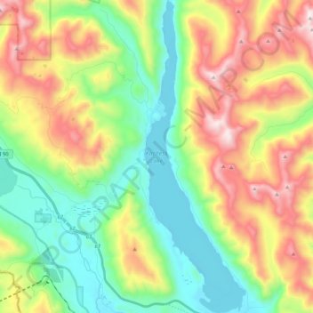
Nom : Carte topographique Kachess Lake, altitude, relief.
Lieu : Kachess Lake, Kittitas County, Washington, United States (47.26445 -121.25551 47.40491 -121.18733)
Altitude moyenne : 1 090 m
Altitude minimum : 677 m
Altitude maximum : 1 770 m
The lake is used as a storage reservoir for the Yakima Project, an irrigation project run by the United States Bureau of Reclamation. Although a natural lake, Kachess Lake's capacity and discharge is controlled by Kachess Dam, a 115-foot (35 m) high earthfill structure built in 1912. The discharge channel for Kachess Reservoir is 2,877 feet long and was constructed from the natural lake to the intake structure of the dam's outlet works, approximately 1800 feet downstream and at a lower elevation than the original lake outlet. The intent of the lowered outlet works was to put all of the average annual runoff into service by adding an additional 76,000 acre feet of natural lake water. As a storage reservoir, Kachess Lake's active capacity is 239,000 acre⋅ft (295 million m3).
Autres cartes topographiques
Cliquez sur une carte pour visualiser sa topographie, son altitude et son relief.
Ellensburg
United States > Washington > Kittitas County > Ellensburg > Ellensburg
Ellensburg, Kittitas County, Washington, 98926, United States
Altitude moyenne : 485 m
Snoqualmie Pass
United States > Washington > Kittitas County
Snoqualmie Pass, Kittitas County, Washington, United States
Altitude moyenne : 955 m
Ellensburg
United States > Washington > Kittitas County
Ellensburg, Kittitas County, Washington, 98926, United States
Altitude moyenne : 480 m
Vantage
United States > Washington > Kittitas County
Vantage, Kittitas County, Washington, United States
Altitude moyenne : 218 m
Four Brothers
United States > Washington > Kittitas County
Four Brothers, Kittitas County, Washington, United States
Altitude moyenne : 1 577 m