
Carte topographique Major Island
Carte interactive
Cliquez sur la carte pour afficher l’altitude.
À propos de cette carte
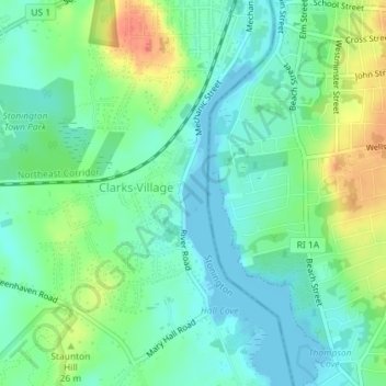
Nom : Carte topographique Major Island, altitude, relief.
Lieu : Major Island, New London County, Connecticut, USA (41.35966 -71.83946 41.36025 -71.83902)
Altitude moyenne : 16 m
Altitude minimum : -2 m
Altitude maximum : 48 m
Autres cartes topographiques
Cliquez sur une carte pour visualiser sa topographie, son altitude et son relief.
The Plans
USA > Connecticut > Norwalk
The Plans, Norwalk, Fairfield, Connecticut, USA
Altitude moyenne : 0 m
Lions Head
Lions Head, Litchfield County, Connecticut, 06968, USA
Altitude moyenne : 403 m
Hartford County
Windsor Locks, Hartford County, Connecticut, 06096, USA
Altitude moyenne : 36 m
Hartford
USA > Connecticut > Hartford
Hartford, Hartford County, Connecticut, USA
Altitude moyenne : 23 m
Barn Island
Barn Island, New London County, Connecticut, 06379, USA
Altitude moyenne : 33 m