
Carte topographique Śnieżka / Sněžka
Carte interactive
Cliquez sur la carte pour afficher l’altitude.
Śnieżka / Sněžka
Due to high altitude the climate is maritime polar (Köppen: ET) not far from a continental subpolar climate (Dfc). The difference should be at least 6 °C lower on annual average compared to the weather station in the plains.
À propos de cette carte
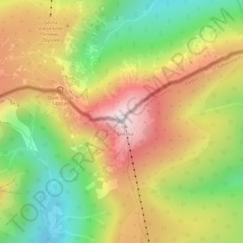
Nom : Carte topographique Śnieżka / Sněžka, altitude, relief.
Altitude moyenne : 1 262 m
Altitude minimum : 938 m
Altitude maximum : 1 596 m
Autres cartes topographiques
Cliquez sur une carte pour visualiser sa topographie, son altitude et son relief.
Karpacz
Poland > Lower Silesian Voivodeship > Karkonosze County > Karpacz
The first settlements in the area of Karpacz are noted by the official website of the city as being of probable Celtic origin and date to the 4th or 3rd century BC when they inhabited the region as part of gold-digging taking place in the area. The area was part of medieval Poland, after the establishment of…
Altitude moyenne : 933 m