
Carte topographique Unkel
Carte interactive
Cliquez sur la carte pour afficher l’altitude.
À propos de cette carte
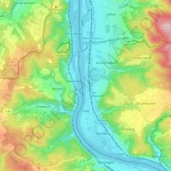
Nom : Carte topographique Unkel, altitude, relief.
Lieu : Unkel, Landkreis Neuwied, Rhineland-Palatinate, Germany (50.58362 7.21001 50.63549 7.31667)
Altitude moyenne : 147 m
Altitude minimum : 50 m
Altitude maximum : 330 m
Autres cartes topographiques
Cliquez sur une carte pour visualiser sa topographie, son altitude et son relief.
Raubach
Germany > Rhineland-Palatinate > Landkreis Neuwied
Raubach, Puderbach, Landkreis Neuwied, Rhineland-Palatinate, Germany
Altitude moyenne : 275 m
Erl
Germany > Rhineland-Palatinate > Landkreis Neuwied > Kasbach-Ohlenberg
Erl, Kasbach-Ohlenberg, Linz am Rhein, Landkreis Neuwied, Rhineland-Palatinate, 53547, Germany
Altitude moyenne : 268 m