
Carte topographique Xinfeng
Carte interactive
Cliquez sur la carte pour afficher l’altitude.
À propos de cette carte
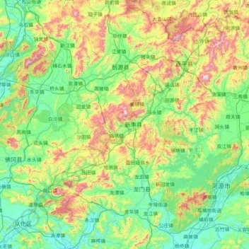
Nom : Carte topographique Xinfeng, altitude, relief.
Lieu : Xinfeng, Shaoguan City, Guangdong, PRC (23.41772 113.51302 24.69772 114.79302)
Altitude moyenne : 310 m
Altitude minimum : 9 m
Altitude maximum : 1 324 m
Autres cartes topographiques
Cliquez sur une carte pour visualiser sa topographie, son altitude et son relief.
Baiyun District
PRC > Guangdong > Guangzhou City
Baiyun District, Guangzhou City, Guangdong, PRC
Altitude moyenne : 40 m
Jinkeng Reservoir
PRC > Guangdong > Guangzhou City > Jinkeng Village
Jinkeng Reservoir, Shuiku Road, Jinkeng Village, Huangpu District, Guangzhou City, Guangdong, PRC
Altitude moyenne : 101 m