
Faire un don
Équipez-vous pour votre prochaine aventure :
En tant que Partenaire Amazon, ce site perçoit une commission sur les achats éligibles sans surcoût pour vous.
Carte topographique Dhemaji
Cliquez sur la carte pour afficher l’altitude.
Faire un don
Équipez-vous pour votre prochaine aventure :
En tant que Partenaire Amazon, ce site perçoit une commission sur les achats éligibles sans surcoût pour vous.
Dhemaji
Dhemaji is located at 27°29′N 94°35′E / 27.48°N 94.58°E / 27.48; 94.58. It has an average elevation of 91 metres (298 feet). Dhemaji is located to the north of the river Brahmaputra. To its north lies the Arunachal Himalayas. To its east lies the state, Arunachal Pradesh and to the west is Lakhimpur, a district of Assam. It has many large and small rivers flowing through it. Some of them are Jiadhal, Gainodi, Dikhari, Dihang, Dimow and Simen. The Subansiri River flows by its western border.
Faire un don
Équipez-vous pour votre prochaine aventure :
En tant que Partenaire Amazon, ce site perçoit une commission sur les achats éligibles sans surcoût pour vous.
À propos de cette carte
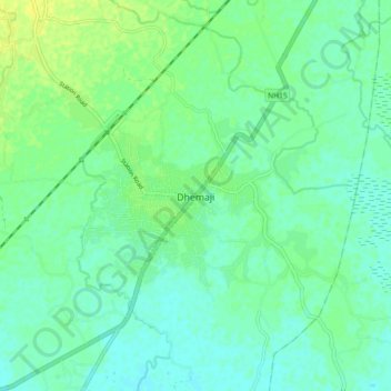
Nom : Carte topographique Dhemaji, altitude, relief.
Lieu : Dhemaji, Assam, 787057, India (27.43638 94.52296 27.51638 94.60296)
Altitude moyenne : 102 m
Altitude minimum : 95 m
Altitude maximum : 112 m
Faire un don
Équipez-vous pour votre prochaine aventure :
En tant que Partenaire Amazon, ce site perçoit une commission sur les achats éligibles sans surcoût pour vous.