
Carte topographique Bethlehem
Carte interactive
Cliquez sur la carte pour afficher l’altitude.
Bethlehem
According to the United States Census Bureau, the town has a total area of 91.0 square miles (235.6 km2), of which 90.6 square miles (234.7 km2) are land and 0.3 square miles (0.9 km2) are water, comprising 0.39% of the town. Bethlehem is drained by the Ammonoosuc, Gale, Zealand and Little rivers, together with Tuttle, Baker and Haystack brooks. Mount Cleveland, elevation 2,397 feet (731 m), and Mount Agassiz, 2,378 ft (725 m), rise to the south of the center of town. Town boundaries contain several of the famous 4,000-footers of New Hampshire: North Twin Mountain (the highest point in Bethlehem at 4,761 ft (1,451 m)), Mount Hale, Mount Tom, Mount Field, and Mount Willey. Bethlehem lies almost fully within the Connecticut River watershed, though a tiny portion of the southeastern corner of the town is in the Merrimack River watershed, and an even smaller portion on the eastern side of the Willey Range is in the Saco River watershed.
À propos de cette carte
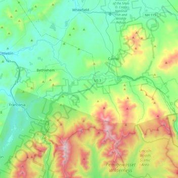
Nom : Carte topographique Bethlehem, altitude, relief.
Altitude moyenne : 528 m
Altitude minimum : 182 m
Altitude maximum : 1 572 m
Autres cartes topographiques
Cliquez sur une carte pour visualiser sa topographie, son altitude et son relief.
Stinson Lake
United States > New Hampshire > Grafton County > Rumney > Stinson Lake
Altitude moyenne : 460 m
Mount Kineo, East Peak
United States > New Hampshire > Grafton County > Ellsworth
Altitude moyenne : 710 m
West Lebanon
United States > New Hampshire > Grafton County > Lebanon > West Lebanon
Altitude moyenne : 165 m
North Littleton
United States > New Hampshire > Grafton County > Littleton > North Littleton
Altitude moyenne : 333 m
LeBruns Mobile Home Park
United States > New Hampshire > Grafton County > Lebanon > LeBruns Mobile Home Park
Altitude moyenne : 326 m