
Carte topographique Naabsiegenhofen
Carte interactive
Cliquez sur la carte pour afficher l’altitude.
À propos de cette carte
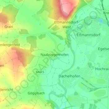
Nom : Carte topographique Naabsiegenhofen, altitude, relief.
Altitude moyenne : 372 m
Altitude minimum : 329 m
Altitude maximum : 453 m
Autres cartes topographiques
Cliquez sur une carte pour visualiser sa topographie, son altitude et son relief.
Klardorf
Deutschland > Bayern > Landkreis Schwandorf > Schwandorf
Klardorf, Schwandorf, Landkreis Schwandorf, Bayern, 93158, Deutschland
Altitude moyenne : 359 m