
Carte topographique Nederland
Carte interactive
Cliquez sur la carte pour afficher l’altitude.
Nederland
In 1873 the Caribou Mine, at an elevation of roughly 10,000 feet (3,000 m) and 6 miles (10 km) northwest of the town, was sold to the Mining Company Nederland from the Netherlands. The high elevation meant fierce winds and deep winter snow, so the new owners of the mine decided that it was beneficial to bring ore from Caribou down to Middle Boulder for milling. In the Dutch language, Nederland ("Netherlands" in English) means low land, and based on casual usage by the Dutch miners, Middle Boulder came to be known as Nederland. In 1874 the town was incorporated and adopted Nederland as the official name.
À propos de cette carte
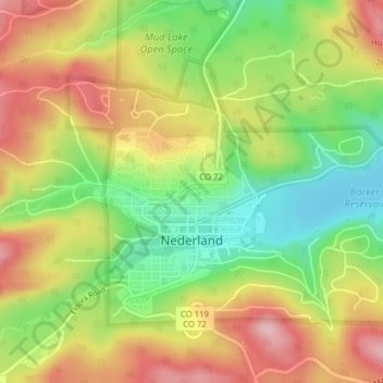
Nom : Carte topographique Nederland, altitude, relief.
Lieu : Nederland, Boulder County, Colorado, 80466, United States (39.95498 -105.52334 39.97532 -105.48418)
Altitude moyenne : 2 578 m
Altitude minimum : 2 482 m
Altitude maximum : 2 677 m
Autres cartes topographiques
Cliquez sur une carte pour visualiser sa topographie, son altitude et son relief.
Boulder
United States > Colorado > Boulder County > Boulder
Boulder is located at the base of the foothills of the Rocky Mountains, at an elevation of 5,430 feet (1,655 m) above sea level. Boulder is 25 miles (40 km) northwest of the Colorado state capital of Denver. It is home of the main campus of the University of Colorado, the state's largest university.
Altitude moyenne : 1 977 m