
Faire un don
Équipez-vous pour votre prochaine aventure :
En tant que Partenaire Amazon, ce site perçoit une commission sur les achats éligibles sans surcoût pour vous.
Carte topographique Saspow
Cliquez sur la carte pour afficher l’altitude.
Faire un don
Équipez-vous pour votre prochaine aventure :
En tant que Partenaire Amazon, ce site perçoit une commission sur les achats éligibles sans surcoût pour vous.
À propos de cette carte
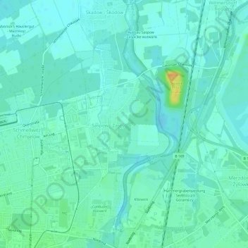
Nom : Carte topographique Saspow, altitude, relief.
Lieu : Saspow, Cottbus, Brandenburg, Deutschland (51.76913 14.34430 51.80598 14.37612)
Altitude moyenne : 68 m
Altitude minimum : 61 m
Altitude maximum : 94 m
Faire un don
Équipez-vous pour votre prochaine aventure :
En tant que Partenaire Amazon, ce site perçoit une commission sur les achats éligibles sans surcoût pour vous.
Autres cartes topographiques
Cliquez sur une carte pour visualiser sa topographie, son altitude et son relief.
Cottbus
Deutschland > Brandenburg > Cottbus
In der Weimarer Republik begegnete man der Wohnungsnot mit staatlichen Programmen. Aber nicht nur preisgünstiger Wohnraum wurde gebraucht, auch die Feuerwehr musste leistungsfähiger werden. Der Bau der neuen Feuerwache trug diesen Anforderungen im einfachen sachlichen Baustil der Moderne Rechnung. Seine…
Altitude moyenne : 79 m