
Carte topographique Andermatt
Carte interactive
Cliquez sur la carte pour afficher l’altitude.
À propos de cette carte
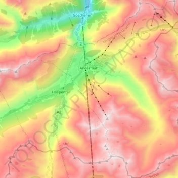
Nom : Carte topographique Andermatt, altitude, relief.
Lieu : Andermatt, Korporation Ursern, Uri, 6490, Switzerland (46.56410 8.54654 46.67706 8.68192)
Altitude moyenne : 2 127 m
Altitude minimum : 1 023 m
Altitude maximum : 2 972 m
Andermatt (Romansh: Ursera (help·info)) is a mountain village and municipality in the canton of Uri in Switzerland. At an elevation of 1,437 meters (4,715 ft) above sea level, Andermatt is located at the center of the Saint-Gotthard Massif and the historical center cross of north-south and east-west traverses of Switzerland. It is some 28 km (17 mi) south of Altdorf, the capital of Uri.
Autres cartes topographiques
Cliquez sur une carte pour visualiser sa topographie, son altitude et son relief.
Realp
Switzerland > Uri > Korporation Ursern
Realp, Korporation Ursern, Uri, 6491, Switzerland
Altitude moyenne : 2 282 m
Hospental
Switzerland > Uri > Korporation Ursern
Hospental, Korporation Ursern, Uri, 6493, Switzerland
Altitude moyenne : 2 144 m