
Faire un don
Équipez-vous pour votre prochaine aventure :
En tant que Partenaire Amazon, ce site perçoit une commission sur les achats éligibles sans surcoût pour vous.
Carte topographique Latina
Cliquez sur la carte pour afficher l’altitude.
Faire un don
Équipez-vous pour votre prochaine aventure :
En tant que Partenaire Amazon, ce site perçoit une commission sur les achats éligibles sans surcoût pour vous.
Latina
The mainland area is, in the south- and north-eastern part, mostly occupied by limestone hills and mountains. Ranges include the Lepini, Aurunci, Ausoni. The highest elevation is that of 1,533-metre (5,030 ft) Monte Petrella (Aurunci). The climate is semi-continental with hot summers and cold winters; temperatures rarely fall below 0 °C (32 °F).
Faire un don
Équipez-vous pour votre prochaine aventure :
En tant que Partenaire Amazon, ce site perçoit une commission sur les achats éligibles sans surcoût pour vous.
À propos de cette carte
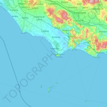
Nom : Carte topographique Latina, altitude, relief.
Lieu : Latina, Lazio, Italy (40.78493 12.53016 41.71483 13.89481)
Altitude moyenne : 103 m
Altitude minimum : -3 m
Altitude maximum : 1 729 m
Faire un don
Équipez-vous pour votre prochaine aventure :
En tant que Partenaire Amazon, ce site perçoit une commission sur les achats éligibles sans surcoût pour vous.
Autres cartes topographiques
Cliquez sur une carte pour visualiser sa topographie, son altitude et son relief.
Rome
Italy > Lazio > Roma Capitale
Although the city centre is about 24 km (15 mi) inland from the Tyrrhenian Sea, the city territory extends to the shore, where the south-western district of Ostia is located. The altitude of the central part of Rome ranges from 13 m (43 ft) above sea level (at the base of the Pantheon) to 139 m (456 ft) above…
Altitude moyenne : 78 m
Monte Cassino
Italy > Lazio > Frosinone > Cassino
Monte Cassino (today usually spelled Montecassino) is a rocky hill about 130 kilometres (80 mi) southeast of Rome, in the Latin Valley, Italy, 2 kilometres (1+1⁄4 mi) west of Cassino and at an elevation of 520 m (1,710 ft). Site of the Roman town of Casinum, it is widely known for its abbey, the first house…
Altitude moyenne : 231 m
Faire un don
Équipez-vous pour votre prochaine aventure :
En tant que Partenaire Amazon, ce site perçoit une commission sur les achats éligibles sans surcoût pour vous.
Palatine Hill
Italy > Lazio > Roma Capitale > Rome
In 2007 the legendary Lupercal cave was claimed to have been found beneath the remains of the Domus Livia (House of Livia) on the Palatine. Archaeologists came across the 16-metre-deep cavity while restoring the decaying palace, with a richly decorated vault encrusted with mosaics and seashells. The Lupercal…
Altitude moyenne : 40 m
Faire un don
Équipez-vous pour votre prochaine aventure :
En tant que Partenaire Amazon, ce site perçoit une commission sur les achats éligibles sans surcoût pour vous.
Villa d'Este
Italy > Lazio > Roma Capitale > Tivoli
Tivoli had been a popular summer residence since ancient Roman times due to its altitude, cooler temperatures and its proximity to the Villa Hadriana, the summer residence of the Emperor Hadrian I. The position of Governor of Tivoli came with an official residence located in a former convent of the Benedictine…
Altitude moyenne : 203 m
Area di sosta turistica Info Point Appia Antica X-XI miglio
Italy > Lazio > Roma Capitale > Marino > Poggio delle Mole
Altitude moyenne : 152 m
Faire un don
Équipez-vous pour votre prochaine aventure :
En tant que Partenaire Amazon, ce site perçoit une commission sur les achats éligibles sans surcoût pour vous.
Monte Gennaro
Italy > Lazio > Roma Capitale > San Polo dei Cavalieri
Monte Gennaro is a peak in the Monti Lucretili, in Lazio, central Italy. It has an elevation of 1,271 metres (4,170 ft) and is the highest peak visible from Rome looking eastwards. It is located in the province of Rome, in the communal territories of Palombara Sabina and San Polo dei Cavalieri.
Altitude moyenne : 930 m
Faire un don
Équipez-vous pour votre prochaine aventure :
En tant que Partenaire Amazon, ce site perçoit une commission sur les achats éligibles sans surcoût pour vous.
Colle Tocciarello
Italy > Lazio > Roma Capitale > Valmontone > Villaggio Rinascita
Altitude moyenne : 278 m
Faire un don
Équipez-vous pour votre prochaine aventure :
En tant que Partenaire Amazon, ce site perçoit une commission sur les achats éligibles sans surcoût pour vous.
Palatine Hill
Italy > Lazio > Roma Capitale > Rome
In 2007 the legendary Lupercal cave was claimed to have been found beneath the remains of the Domus Livia (House of Livia) on the Palatine. Archaeologists came across the 16-metre-deep cavity while restoring the decaying palace, with a richly decorated vault encrusted with mosaics and seashells. The Lupercal…
Altitude moyenne : 40 m
Faire un don
Équipez-vous pour votre prochaine aventure :
En tant que Partenaire Amazon, ce site perçoit une commission sur les achats éligibles sans surcoût pour vous.
Faire un don
Équipez-vous pour votre prochaine aventure :
En tant que Partenaire Amazon, ce site perçoit une commission sur les achats éligibles sans surcoût pour vous.
Faire un don
Équipez-vous pour votre prochaine aventure :
En tant que Partenaire Amazon, ce site perçoit une commission sur les achats éligibles sans surcoût pour vous.
Faire un don
Équipez-vous pour votre prochaine aventure :
En tant que Partenaire Amazon, ce site perçoit une commission sur les achats éligibles sans surcoût pour vous.
Faire un don
Équipez-vous pour votre prochaine aventure :
En tant que Partenaire Amazon, ce site perçoit une commission sur les achats éligibles sans surcoût pour vous.
Faire un don
Équipez-vous pour votre prochaine aventure :
En tant que Partenaire Amazon, ce site perçoit une commission sur les achats éligibles sans surcoût pour vous.
Faire un don
Équipez-vous pour votre prochaine aventure :
En tant que Partenaire Amazon, ce site perçoit une commission sur les achats éligibles sans surcoût pour vous.