
Carte topographique Jashpur
Carte interactive
Cliquez sur la carte pour afficher l’altitude.
À propos de cette carte
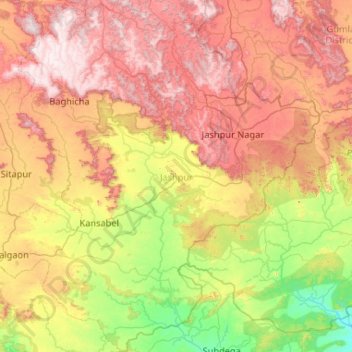
Nom : Carte topographique Jashpur, altitude, relief.
Lieu : Jashpur, Chhattisgarh, Inde (22.28818 83.38676 23.24457 84.39596)
Altitude moyenne : 603 m
Altitude minimum : 215 m
Altitude maximum : 1 150 m
Autres cartes topographiques
Cliquez sur une carte pour visualiser sa topographie, son altitude et son relief.
Jashpur Tahsil
Jashpur Tahsil, Jashpur District, Chhattisgarh, Inde
Altitude moyenne : 712 m
Nava Raipur Atal Nagar
Inde > Chhattisgarh > Nava Raipur Atal Nagar
Nava Raipur Atal Nagar, Arang Tahsil, Raipur, Chhattisgarh, Inde
Altitude moyenne : 305 m
Kanker
Inde > Chhattisgarh > Kanker
Kanker, Kanker Tahsil, Uttar Bastar Kanker, Chhattisgarh, 494334, Inde
Altitude moyenne : 405 m
Bilaspur
Inde > Chhattisgarh > Bilaspur
Bilaspur, Bilāspur, Bilaspur, Chhattisgarh, 495004, Inde
Altitude moyenne : 270 m