
Carte topographique Londonderry Island
Carte interactive
Cliquez sur la carte pour afficher l’altitude.
À propos de cette carte
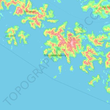
Nom : Carte topographique Londonderry Island, altitude, relief.
Altitude moyenne : 68 m
Altitude minimum : -5 m
Altitude maximum : 867 m
Autres cartes topographiques
Cliquez sur une carte pour visualiser sa topographie, son altitude et son relief.
Cape Horn
Chile > XII Region of Magallanes and Chilean Antarctica > Cape Horn
Cape Horn, Provincia de la Antártica Chilena, XII Region of Magallanes and Chilean Antarctica, Chile
Altitude moyenne : 39 m