
Carte topographique Lake Rotomā
Carte interactive
Cliquez sur la carte pour afficher l’altitude.
À propos de cette carte
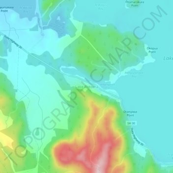
Nom : Carte topographique Lake Rotomā, altitude, relief.
Lieu : Lake Rotomā, Bay of Plenty, New Zealand (-38.07051 176.54247 -38.03051 176.58247)
Altitude moyenne : 362 m
Altitude minimum : 297 m
Altitude maximum : 583 m
Autres cartes topographiques
Cliquez sur une carte pour visualiser sa topographie, son altitude et son relief.
Whakarewarewa Lagoon
New Zealand > Bay of Plenty > Lake Rotomā
Whakarewarewa Lagoon, Manawahe Road, Lake Rotomā, Rotorua District, Bay of Plenty, New Zealand
Altitude moyenne : 335 m