
Carte topographique Gorges State Park
Carte interactive
Cliquez sur la carte pour afficher l’altitude.
À propos de cette carte
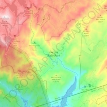
Nom : Carte topographique Gorges State Park, altitude, relief.
Altitude moyenne : 682 m
Altitude minimum : 329 m
Altitude maximum : 1 081 m
Following the flood, local citizens eventually sold large land tracts in the Gorges to Singer Sewing Machine Company, which logged most of the land. Then, in the 1940s and 1950s, Singer sold the land to Duke Energy Corporation. The corporation purchased the land for its steep topography and high rainfall, which offered opportunities for development of hydropower projects.
Autres cartes topographiques
Cliquez sur une carte pour visualiser sa topographie, son altitude et son relief.
Middle Mountain
United States > North Carolina > Transylvania County
Middle Mountain, Transylvania County, North Carolina, United States
Altitude moyenne : 916 m
Brevard
United States > North Carolina > Transylvania County
Brevard, Transylvania County, North Carolina, United States
Altitude moyenne : 745 m
North Brevard
United States > North Carolina > Transylvania County > North Brevard
North Brevard, Transylvania County, North Carolina, 28768, United States
Altitude moyenne : 673 m