
Carte topographique Covington
Carte interactive
Cliquez sur la carte pour afficher l’altitude.
À propos de cette carte
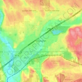
Nom : Carte topographique Covington, altitude, relief.
Lieu : Covington, King County, Washington, 98042, United States (47.34401 -122.14398 47.38727 -122.05882)
Altitude moyenne : 137 m
Altitude minimum : 89 m
Altitude maximum : 188 m
Autres cartes topographiques
Cliquez sur une carte pour visualiser sa topographie, son altitude et son relief.
Burien
United States > Washington > King County
Burien, King County, Washington, United States
Altitude moyenne : 65 m
Twin Falls (Lower)
United States > Washington > King County
Twin Falls (Lower), King County, Washington, 98045, United States
Altitude moyenne : 458 m
Bothell
United States > Washington > King County > Bothell
Bothell, King County, Washington, United States
Altitude moyenne : 68 m
Seattle
United States > Washington > King County
Seattle, King County, Washington, United States
Altitude moyenne : 40 m
Bellevue
United States > Washington > King County
Bellevue, King County, Washington, United States
Altitude moyenne : 66 m