
Carte topographique Gananoque Lake
Carte interactive
Cliquez sur la carte pour afficher l’altitude.
À propos de cette carte
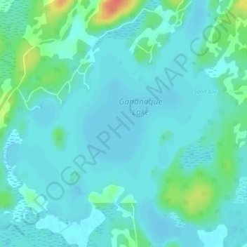
Nom : Carte topographique Gananoque Lake, altitude, relief.
Altitude moyenne : 90 m
Altitude minimum : 81 m
Altitude maximum : 130 m
Autres cartes topographiques
Cliquez sur une carte pour visualiser sa topographie, son altitude et son relief.
Gananoque River
Canada > Ontario > Leeds and the Thousand Islands > Willowbank
Gananoque River, Turn Around Road, Willowbank, Leeds and the Thousand Islands, Leeds and Grenville Counties, Eastern Ontario, Ontario, K7G 1G4, Canada
Altitude moyenne : 92 m
Southern Water
Canada > Ontario > Leeds and the Thousand Islands > Outlet
Southern Water, Outlet, Leeds and the Thousand Islands, Leeds and Grenville Counties, Eastern Ontario, Ontario, Canada
Altitude moyenne : 93 m
Ivy Lea
Canada > Ontario > Leeds and the Thousand Islands > Ivy Lea
Ivy Lea, Leeds and the Thousand Islands, Leeds and Grenville Counties, Eastern Ontario, Ontario, K0E 1L0, Canada
Altitude moyenne : 87 m
Gananoque Lake
Canada > Ontario > Leeds and the Thousand Islands
Gananoque Lake, Deryaw Road, Leeds and the Thousand Islands, Leeds and Grenville Counties, Eastern Ontario, Ontario, K0H 2N0, Canada
Altitude moyenne : 92 m