
Faire un don
Équipez-vous pour votre prochaine aventure :
En tant que Partenaire Amazon, ce site perçoit une commission sur les achats éligibles sans surcoût pour vous.
Carte topographique Lewis Pass
Cliquez sur la carte pour afficher l’altitude.
Faire un don
Équipez-vous pour votre prochaine aventure :
En tant que Partenaire Amazon, ce site perçoit une commission sur les achats éligibles sans surcoût pour vous.
Lewis Pass
Lewis Pass is the northernmost of the three main mountain passes through the Southern Alps in the South Island of New Zealand. With an elevation of 907 metres, it is slightly lower than Arthur's Pass and higher than Haast Pass.
Faire un don
Équipez-vous pour votre prochaine aventure :
En tant que Partenaire Amazon, ce site perçoit une commission sur les achats éligibles sans surcoût pour vous.
À propos de cette carte
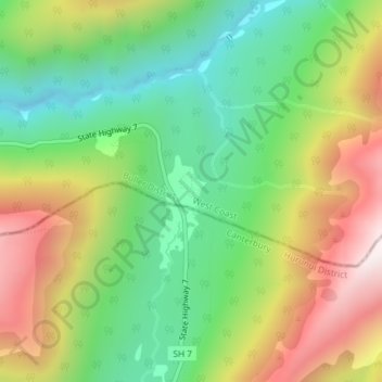
Nom : Carte topographique Lewis Pass, altitude, relief.
Lieu : Lewis Pass, Buller District, West Coast, New Zealand (-42.37855 172.40098 -42.37845 172.40108)
Altitude moyenne : 1 039 m
Altitude minimum : 680 m
Altitude maximum : 1 547 m
Faire un don
Équipez-vous pour votre prochaine aventure :
En tant que Partenaire Amazon, ce site perçoit une commission sur les achats éligibles sans surcoût pour vous.
Autres cartes topographiques
Cliquez sur une carte pour visualiser sa topographie, son altitude et son relief.