
Carte topographique Władysławowo
Carte interactive
Cliquez sur la carte pour afficher l’altitude.
À propos de cette carte
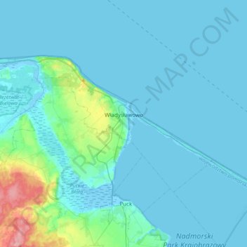
Nom : Carte topographique Władysławowo, altitude, relief.
Lieu : Władysławowo, Puck County, Pomeranian Voivodeship, Poland (54.72948 18.19442 54.83642 18.52934)
Altitude moyenne : 11 m
Altitude minimum : -5 m
Altitude maximum : 108 m
Autres cartes topographiques
Cliquez sur une carte pour visualiser sa topographie, son altitude et son relief.
Puck
Poland > Pomeranian Voivodeship > Puck County
Puck, Puck County, Pomeranian Voivodeship, Poland
Altitude moyenne : 5 m
Dębki
Poland > Pomeranian Voivodeship > Puck County
Dębki, gmina Krokowa, Puck County, Pomeranian Voivodeship, 84-110, Poland
Altitude moyenne : 0 m
Hel
Poland > Pomeranian Voivodeship > Puck County
Hel, Puck County, Pomeranian Voivodeship, 84-150, Poland
Altitude moyenne : 0 m
Puck
Poland > Pomeranian Voivodeship > Puck County > Puck
Puck, Puck County, Pomeranian Voivodeship, 84-100, Poland
Altitude moyenne : 9 m