
Carte topographique Annette Island
Carte interactive
Cliquez sur la carte pour afficher l’altitude.
À propos de cette carte
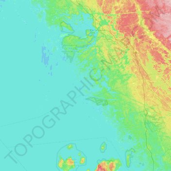
Nom : Carte topographique Annette Island, altitude, relief.
Altitude moyenne : 198 m
Altitude minimum : 172 m
Altitude maximum : 324 m
Autres cartes topographiques
Cliquez sur une carte pour visualiser sa topographie, son altitude et son relief.
Doll Island
Canada > Ontario > The Archipelago
Doll Island, The Archipelago, Parry Sound District, Ontario, Canada
Altitude moyenne : 200 m
Skye Island
Canada > Ontario > The Archipelago
Skye Island, The Archipelago, Parry Sound District, Ontario, Canada
Altitude moyenne : 199 m
St. Helens Island
Canada > Ontario > The Archipelago
St. Helens Island, The Archipelago, Parry Sound District, Ontario, Canada
Altitude moyenne : 189 m