
Carte topographique Icaria
Carte interactive
Cliquez sur la carte pour afficher l’altitude.
À propos de cette carte
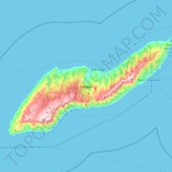
Nom : Carte topographique Icaria, altitude, relief.
Lieu : Icaria, Ikaria Regional Unit, Northern Aegean, Aegean, Greece (37.50869 25.97381 37.69119 26.36565)
Altitude moyenne : 87 m
Altitude minimum : 0 m
Altitude maximum : 1 027 m
Icaria is one of the middle islands of the northern Aegean, 255.303 square kilometres (98.573 sq mi) in area with 102 miles (164 kilometres) of coastline and a population of 8,312 inhabitants. The topography is a contrast between verdant slopes and barren steep rocks. The island is mountainous for the most part. It is traversed by the Aetheras range, whose highest summit is 1,037 metres (3,402 feet). Most of its villages are nestled in the plains near the coast, with some in the mountains.