
Carte topographique Pamlico County
Carte interactive
Cliquez sur la carte pour afficher l’altitude.
À propos de cette carte
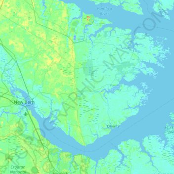
Nom : Carte topographique Pamlico County, altitude, relief.
Lieu : Pamlico County, North Carolina, United States (34.95030 -76.98758 35.36043 -76.30414)
Altitude moyenne : 5 m
Altitude minimum : -11 m
Altitude maximum : 39 m
The county was formed in 1872 from parts of Beaufort and Craven counties. It was named for Pamlico Sound, which adjoins it. Vernacular usage in the area, especially in Craven County, refers to Pamlico County as being "down in the county." Prior to 1872, it was a part of Craven County and has a very low elevation. Most of the county, according to FRIS, North Carolina Flood Risk Information System, is subject to flooding in storm surges. After it was separated from Craven, the old nickname survives. Pamlico County remains rural in character and flavor, although the last decade has brought a good deal of residential development, largely the result of northern retirees and investors attracted to the many miles of waterfront property.
Autres cartes topographiques
Cliquez sur une carte pour visualiser sa topographie, son altitude et son relief.
Vandemere
United States > North Carolina > Pamlico County
Vandemere, Pamlico County, North Carolina, 28587, United States
Altitude moyenne : 2 m
Oriental
United States > North Carolina > Pamlico County
Oriental, Pamlico County, North Carolina, United States
Altitude moyenne : 3 m
Alliance
United States > North Carolina > Pamlico County
Alliance, Pamlico County, North Carolina, United States
Altitude moyenne : 4 m
Ball Creek
United States > North Carolina > Pamlico County > Florence
Ball Creek, Florence, Pamlico County, North Carolina, 28556, United States
Altitude moyenne : 2 m